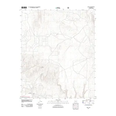
2011 Map of Riley
USGS Topo · Published 2011About this map
Riley sits near the southwestern edge of this high-desert quadrangle, positioned just north of the Rio Salado as it winds through a landscape of deep canyons and prominent peaks. The topography is dominated by dramatic elevations like Yellow Mountain and Brown, with the complex drainage of Cañon del Tanque Hondo cutting through the terrain. A portion of the Cibola National Forest covers the southwestern corner, reflecting the transition from open grazing land to protected mountainous territory. The road network is sparse, defined by rugged routes like County Rd-12 and Forest-354-Rd, which provide access to remote landmarks such as Romero. This 2011 survey documents a region where settlement is minimal and the physical environment, characterized by steep elevation shifts and ephemeral watercourses, dictates the pattern of human movement and land use.
Find a feature on this map
10 named features on this map. Tap any name to fly to it.
Don’t see what you’re looking for? This feature index may not catch every label — zoom into the map to look around manually.
Map Details
Editions of this 2011 Riley Map
This is the sole edition of this map. No revisions or reprints were ever made.
Other maps of this area

1917 · Cerro Verde
USGS Topo · 1:125,000

1954 · Socorro
USGS Topo · 1:250,000

1956 · Mesa Aparejo
USGS Topo · 1:62,500

1958 · Socorro
USGS Topo · 1:250,000

1959 · Riley
USGS Topo · 1:62,500

1962 · Socorro
USGS Topo · 1:250,000

1964 · La Jara Peak
USGS Topo · 1:24,000
1964 · Puerto De Los Cavadores
USGS Topo · 1:24,000
1964 · Mesa Cencerro
USGS Topo · 1:24,000
1978 · Acoma Pueblo
USGS Topo · 1:100,000