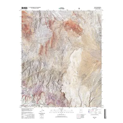
2017 Map of Riley
USGS Topo · Published 2017About this map
The settlement of Riley marks a quiet point of human presence in this high-desert landscape, located just outside the northern boundary of the Cibola National Forest. The geography is defined by significant elevation changes and dry watercourses, most notably the winding Coyote Draw and the Cañon del Tanque Hondo which cuts through the southern reaches. This modern topographic study shows a territory where travel is dictated by the land's contours, with Co Rd 51 and Co Rd 12 providing the primary access through the desert flats and arroyos. Dominant natural landmarks like Sierra Lucero and Yellow Mtn provide essential orientation in a region characterized by sparse vegetation and vast open space, reflecting the enduring character of Socorro County's rural backcountry.
Find a feature on this map
14 named features on this map. Tap any name to fly to it.
Don’t see what you’re looking for? This feature index may not catch every label — zoom into the map to look around manually.
Map Details
Editions of this 2017 Riley Map
This is the sole edition of this map. No revisions or reprints were ever made.
Other maps of this area

1917 · Cerro Verde
USGS Topo · 1:125,000

1954 · Socorro
USGS Topo · 1:250,000

1956 · Mesa Aparejo
USGS Topo · 1:62,500

1958 · Socorro
USGS Topo · 1:250,000

1959 · Riley
USGS Topo · 1:62,500

1962 · Socorro
USGS Topo · 1:250,000

1964 · La Jara Peak
USGS Topo · 1:24,000
1964 · Puerto De Los Cavadores
USGS Topo · 1:24,000
1964 · Mesa Cencerro
USGS Topo · 1:24,000
1978 · Acoma Pueblo
USGS Topo · 1:100,000