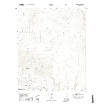
2020 Map of Riley
USGS Topo · Published 2020About this map
Riley sits at the southern edge of this Socorro County landscape, positioned near the seasonal course of the Rio Salado. The terrain is defined by dramatic elevation shifts and geological features, including the prominent heights of Sierra Lucero and Yellow Mtn. This high-desert environment is deeply etched by drainage systems like Coyote Draw and the steep-walled Cañon del Tanque Hondo, which channel water toward the river valley during the monsoon season. A portion of the Cibola National Forest occupies the southwestern corner of the quadrangle, where the grid of Forest Rd and local routes like Co Rd 12 navigate the complex topography. The map illustrates a region of transition between open range and the protected timberlands of the national forest, reflecting the isolated ranching and grazing character of this part of New Mexico.
Find a feature on this map
14 named features on this map. Tap any name to fly to it.
Don’t see what you’re looking for? This feature index may not catch every label — zoom into the map to look around manually.
Map Details
Editions of this 2020 Riley Map
This is the sole edition of this map. No revisions or reprints were ever made.
Other maps of this area

1917 · Cerro Verde
USGS Topo · 1:125,000

1954 · Socorro
USGS Topo · 1:250,000

1956 · Mesa Aparejo
USGS Topo · 1:62,500

1958 · Socorro
USGS Topo · 1:250,000

1959 · Riley
USGS Topo · 1:62,500

1962 · Socorro
USGS Topo · 1:250,000

1964 · La Jara Peak
USGS Topo · 1:24,000
1964 · Puerto De Los Cavadores
USGS Topo · 1:24,000
1964 · Mesa Cencerro
USGS Topo · 1:24,000
1978 · Acoma Pueblo
USGS Topo · 1:100,000