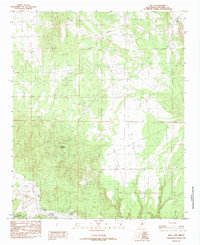
1985 Map of Riley
USGS Topo · Published 1985About this map
Yellow Mountain dominates the southwestern portion of this Socorro County landscape, rising above the ephemeral watercourses that define the region's drainage. The arid terrain is marked by the seasonal flow of Coyote Draw and the more significant Rio Salado, which cuts across the southern edge of the sheet. This 1985 survey illustrates a sparsely populated area where human activity is primarily indicated by several scattered Prospects, suggesting localized mineral exploration or small-scale mining efforts typical of this high-desert environment. A portion of the Cibola National Forest is situated in the southwest corner, providing a contrast between managed federal lands and the surrounding open territory. The map serves as a detailed record of topographical elevations and the network of unimproved roads and trails that connected these remote points in the mid-1980s.
Find a feature on this map
5 named features on this map. Tap any name to fly to it.
Don’t see what you’re looking for? This feature index may not catch every label — zoom into the map to look around manually.
Map Details
Editions of this 1985 Riley Map
This is the sole edition of this map. No revisions or reprints were ever made.
Other maps of this area

1917 · Cerro Verde
USGS Topo · 1:125,000

1954 · Socorro
USGS Topo · 1:250,000

1956 · Mesa Aparejo
USGS Topo · 1:62,500

1958 · Socorro
USGS Topo · 1:250,000

1959 · Riley
USGS Topo · 1:62,500

1962 · Socorro
USGS Topo · 1:250,000

1964 · La Jara Peak
USGS Topo · 1:24,000
1964 · Puerto De Los Cavadores
USGS Topo · 1:24,000
1964 · Mesa Cencerro
USGS Topo · 1:24,000
1978 · Acoma Pueblo
USGS Topo · 1:100,000