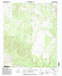
1995 Map of Riley
USGS Topo · Published 1998About this map
Riley sits at the base of Yellow Mountain along the southern edge of this mid-1990s survey, marking a pocket of settlement within the northern reaches of the Cibola National Forest. The landscape is defined by the sharp transition between the drainages of Coyote Draw and the Rio Salado, where the high elevations of Mesa Lucero and the Sierra Lucero overlook the basin.
Find a feature on this map
13 named features on this map. Tap any name to fly to it.
Don’t see what you’re looking for? This feature index may not catch every label — zoom into the map to look around manually.
Map Details
Editions of this 1995 Riley Map
This is the sole edition of this map. No revisions or reprints were ever made.
Other maps of this area

1917 · Cerro Verde
USGS Topo · 1:125,000

1954 · Socorro
USGS Topo · 1:250,000

1956 · Mesa Aparejo
USGS Topo · 1:62,500

1958 · Socorro
USGS Topo · 1:250,000

1959 · Riley
USGS Topo · 1:62,500

1962 · Socorro
USGS Topo · 1:250,000

1964 · La Jara Peak
USGS Topo · 1:24,000
1964 · Puerto De Los Cavadores
USGS Topo · 1:24,000
1964 · Mesa Cencerro
USGS Topo · 1:24,000
1978 · Acoma Pueblo
USGS Topo · 1:100,000