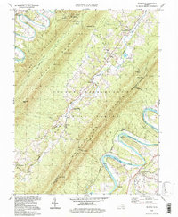
1994 Map of Rileyville
USGS Topo · Published 1997About this map
Massanutten Mountain dominates this mid-1990s terrain, creating a natural divide between the North Fork and South Fork of the Shenandoah River. In the valley between these ridges, the George Washington National Forest shelters numerous small mountain gaps like Red Spring Gap and Habron Gap. Settlement patterns follow the winding course of Passage Creek, where community life centers around the Port Valley Sch and a series of historic houses of worship, including Saint Davids Church and the White Chapel.
Find a feature on this map
59 named features on this map. Tap any name to fly to it.
Don’t see what you’re looking for? This feature index may not catch every label — zoom into the map to look around manually.
Map Details
Editions of this 1994 Rileyville Map
This is the sole edition of this map. No revisions or reprints were ever made.
Other maps of this area

1892 · Woodstock
USGS Topo · 1:125,000

1893 · Luray
USGS Topo · 1:125,000

1905 · Luray
USGS Topo · 1:125,000

1923 · Edinburg
USGS Topo · 1:62,500

1929 · Stony Man
USGS Topo · 1:48,000

1933 · Stony Man
USGS Topo · 1:62,500

1942 · Mt Jackson
USGS Topo · 1:62,500

1946 · Mt Jackson
USGS Topo · 1:62,500

1947 · Mt Jackson
USGS Topo · 1:62,500

1947 · Strasburg
USGS Topo · 1:62,500