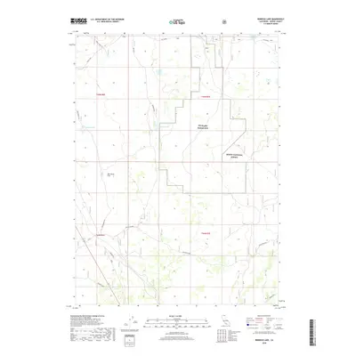
2018 Map of Rimrock Lake
USGS Topo · Published 2018About this map
Tulelake Radar Site occupies a central position within this portion of the Modoc National Forest in northern California. The landscape is defined by the volcanic and high-desert geography of Modoc County, featuring prominent relief at Rim Rock and its associated Rimrock Spur. This 2018 survey reveals a terrain primarily used for resource management and ranching, evidenced by the expansive Potter Pasture and the named landing at Bob Young Flat. Numerous small basins and depressions hold seasonal or permanent water bodies, including the central Rimrock Lake, Clear Lake, Cummins Lake, and Double Head Lake. Local infrastructure is sparse, limited to specialized sites like the Harvey Jones Pit, the Badger Well, and the forest road Tionesta East, reflecting a remote and utilitarian land-use pattern.
Find a feature on this map
18 named features on this map. Tap any name to fly to it.
Don’t see what you’re looking for? This feature index may not catch every label — zoom into the map to look around manually.
Map Details
Editions of this 2018 Rimrock Lake Map
This is the sole edition of this map. No revisions or reprints were ever made.
Other maps of this area

1886 · Modoc Lava Bed
USGS Topo · 1:250,000

1892 · Modoc Lava-Bed
USGS Topo · 1:250,000

1951 · Clear Lake Reservoir
USGS Topo · 1:62,500

1951 · Tulelake
USGS Topo · 1:62,500

1952 · Timber Mountain
USGS Topo · 1:62,500

1952 · Hackamore
USGS Topo · 1:62,500

1954 · Alturas
USGS Topo · 1:250,000

1958 · Alturas
USGS Topo · 1:250,000

1962 · Alturas
USGS Topo · 1:250,000

1965 · Alturas
USGS Topo · 1:250,000