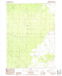
1988 Map of Rimrock Lake
USGS Topo · Published 1988About this map
Modoc National Forest encompasses this high plateau landscape, where water sources were the vital anchors for activity in the late 20th century. Named landmarks such as Bob Young Flat and Horse Camp indicate a history of ranching and seasonal land use. The topography is dotted with small, isolated water bodies including Rimrock Lake, Double Head Lake, and Cummins Lake, which provided essential resources in this arid region of Northern California. The mapping of Flukey Well and Potters Well further emphasizes the importance of reliable water points for both livestock and forest management. This 1988 provisional survey preserves the placement of these functional landmarks before more modern developments or environmental shifts altered the distribution of these small upland basins.
Find a feature on this map
11 named features on this map. Tap any name to fly to it.
Don’t see what you’re looking for? This feature index may not catch every label — zoom into the map to look around manually.
Map Details
Editions of this 1988 Rimrock Lake Map
This is the sole edition of this map. No revisions or reprints were ever made.
Other maps of this area

1886 · Modoc Lava Bed
USGS Topo · 1:250,000

1892 · Modoc Lava-Bed
USGS Topo · 1:250,000

1951 · Clear Lake Reservoir
USGS Topo · 1:62,500

1951 · Tulelake
USGS Topo · 1:62,500

1952 · Timber Mountain
USGS Topo · 1:62,500

1952 · Hackamore
USGS Topo · 1:62,500

1954 · Alturas
USGS Topo · 1:250,000

1958 · Alturas
USGS Topo · 1:250,000

1962 · Alturas
USGS Topo · 1:250,000

1965 · Alturas
USGS Topo · 1:250,000