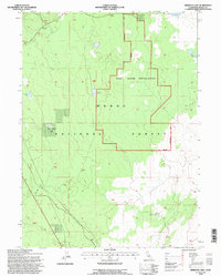
1993 Map of Rimrock Lake
USGS Topo · Published 1996About this map
The Modoc National Forest dominates this northern California landscape, defined by a mix of high-altitude basins and specialized infrastructure as it appeared in the early 1990s. A significant portion of the terrain is occupied by the OTHB Radar Installation, a Cold War-era Over-the-Horizon Backscatter facility enclosed by a Military Reservation Boundary. This specialized installation reflects the region's strategic importance during the late twentieth century, situated amidst a network of natural and improved water sources.
Find a feature on this map
15 named features on this map. Tap any name to fly to it.
Don’t see what you’re looking for? This feature index may not catch every label — zoom into the map to look around manually.
Map Details
Editions of this 1993 Rimrock Lake Map
This is the sole edition of this map. No revisions or reprints were ever made.
Other maps of this area

1886 · Modoc Lava Bed
USGS Topo · 1:250,000

1892 · Modoc Lava-Bed
USGS Topo · 1:250,000

1951 · Clear Lake Reservoir
USGS Topo · 1:62,500

1951 · Tulelake
USGS Topo · 1:62,500

1952 · Timber Mountain
USGS Topo · 1:62,500

1952 · Hackamore
USGS Topo · 1:62,500

1954 · Alturas
USGS Topo · 1:250,000

1958 · Alturas
USGS Topo · 1:250,000

1962 · Alturas
USGS Topo · 1:250,000

1965 · Alturas
USGS Topo · 1:250,000