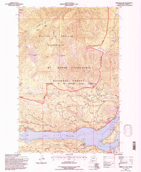
1992 Map of Rimrock Lake
USGS Topo · Published 1996About this map
Rimrock Lake dominates the lower third of this 1990s landscape, serving as a central catchment for the North Fork and South Fork as they transition into the Tieton River. The map captures a high-elevation backcountry managed across several jurisdictions, including the William O Douglas Wilderness and the Mt Baker-Snoqualmie National Forest. Topographic details reveal a network of high ridges and peaks such as Russell Ridge and Ironstone Mtn, which define the drainage basins for Rattlesnake Creek and Wildcat Creek.
Find a feature on this map
27 named features on this map. Tap any name to fly to it.
Don’t see what you’re looking for? This feature index may not catch every label — zoom into the map to look around manually.
Map Details
Editions of this 1992 Rimrock Lake Map
This is the sole edition of this map. No revisions or reprints were ever made.
Other maps of this area

1902 · Mount Aix
USGS Topo · 1:125,000

1904 · Mt Aix
USGS Topo · 1:125,000

1950 · Yakima
USGS Topo · 1:250,000

1958 · Yakima
USGS Topo · 1:250,000

1961 · Yakima
USGS Topo · 1:250,000

1962 · Bumping Lake
USGS Topo · 1:62,500

1962 · White Pass
USGS Topo · 1:62,500

1967 · Rimrock Lake
USGS Topo · 1:24,000

1967 · Tieton Basin
USGS Topo · 1:24,000

1967 · Darland Mtn
USGS Topo · 1:24,000