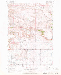
1956 Map of Rimrock
USGS Topo · Published 1971About this map
The Rimrocks formation dominates the central landscape of this Yellowstone County survey, creating a sharp topographical divide between the upland plateaus and the valley floor. In the mid-1950s, this area functioned as a critical corridor for transport and irrigation, evidenced by the parallel tracks of the Northern Pacific and Great Northern railroads. These rail lines follow the path of Canyon Creek, while a network of water management features like the Great Northern Ditch and Big Snow Ditch supported the local agricultural economy.
Find a feature on this map
25 named features on this map. Tap any name to fly to it.
Don’t see what you’re looking for? This feature index may not catch every label — zoom into the map to look around manually.
Map Details
Editions of this 1956 Rimrock Map
3 editions found
Other maps of this area

1954 · Billings
USGS Topo · 1:250,000

1956 · Comanche
USGS Topo · 1:24,000

1956 · Acton
USGS Topo · 1:24,000

1956 · Hickson Ranch
USGS Topo · 1:24,000

1956 · Rimrock
USGS Topo · 1:24,000

1956 · Two Pine School
USGS Topo · 1:24,000

1956 · Laurel
USGS Topo · 1:24,000

1956 · Yegen
USGS Topo · 1:24,000

1956 · Mossmain
USGS Topo · 1:24,000

1957 · Billings
USGS Topo · 1:250,000