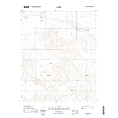
2020 Map of Rincon Hondo
USGS Topo · Published 2020About this map
Santa Rita Mesa dominates the southern portion of this high-desert landscape in Cibola County, where the topography is defined by dramatic elevation changes and a network of deep drainage systems. The area is marked by substantial geographic features like Rincon Hondo and Provenger Rincon, which reflect the erosion patterns characteristic of the New Mexico interior. Water sources are scarce but critical, appearing as isolated points such as Jaralosa Spring, Zuni Spring, and Canyon Springs. These features, along with man-made catchments like Cabin Tank and Perry Lake, illustrate the vital infrastructure required for ranching or land management in this arid environment. The map provides a clear picture of the land's transition from open draws like Jaralosa Draw to the steep walls of Zuni Canyon and Rincon Hondo Canyon.
Find a feature on this map
18 named features on this map. Tap any name to fly to it.
Don’t see what you’re looking for? This feature index may not catch every label — zoom into the map to look around manually.
Map Details
Editions of this 2020 Rincon Hondo Map
This is the sole edition of this map. No revisions or reprints were ever made.
Other maps of this area

1954 · Saint Johns
USGS Topo · 1:250,000

1957 · Saint Johns
USGS Topo · 1:250,000

1958 · Saint Johns
USGS Topo · 1:250,000

1962 · Saint Johns
USGS Topo · 1:250,000

1972 · Twentytwo Spring
USGS Topo · 1:24,000

1972 · Fence Lake
USGS Topo · 1:24,000

1972 · Fence Lake SW
USGS Topo · 1:24,000
1972 · Mesita De Yeso
USGS Topo · 1:24,000

1972 · Cantaralo Spring
USGS Topo · 1:24,000
1972 · Atarque Lake
USGS Topo · 1:24,000