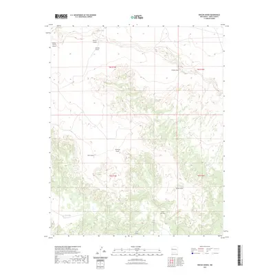
2023 Map of Rincon Hondo
USGS Topo · Published 2023About this map
Santa Rita Mesa and the surrounding tablelands of Cibola County define this high-desert landscape in west-central New Mexico. The terrain is marked by a complex system of drainages and topographic breaks, most notably the deep incisions of Rincon Hondo Canyon and Atarque Canyon to the north. These canyons, along with Zuni Canyon in the south, demonstrate the erosional patterns of the Colorado Plateau, where ephemeral water sources are vital landmarks. Evidence of these critical water points is found at Jaralosa Spring, Los Alamos Springs, and the intermittent Perry Lake. The presence of man-made improvements like Cabin Tank alongside natural features such as Jaralosa Draw indicates a long-standing reliance on carefully managed water resources for ranching or land use in this arid region.
Find a feature on this map
18 named features on this map. Tap any name to fly to it.
Don’t see what you’re looking for? This feature index may not catch every label — zoom into the map to look around manually.
Map Details
Editions of this 2023 Rincon Hondo Map
This is the sole edition of this map. No revisions or reprints were ever made.
Other maps of this area

1954 · Saint Johns
USGS Topo · 1:250,000

1957 · Saint Johns
USGS Topo · 1:250,000

1958 · Saint Johns
USGS Topo · 1:250,000

1962 · Saint Johns
USGS Topo · 1:250,000

1972 · Twentytwo Spring
USGS Topo · 1:24,000

1972 · Fence Lake
USGS Topo · 1:24,000

1972 · Fence Lake SW
USGS Topo · 1:24,000
1972 · Mesita De Yeso
USGS Topo · 1:24,000

1972 · Cantaralo Spring
USGS Topo · 1:24,000
1972 · Atarque Lake
USGS Topo · 1:24,000