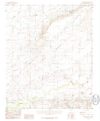
1986 Map of Rincon Ranch
USGS Topo · Published 1986About this map
Ives Mesa dominates the landscape of this Navajo County ranchland, rising between the Rincon Basin to the northwest and a network of drainage channels to the south. The area is defined by the vital necessity of water in an arid environment, as evidenced by the namesake Rincon Ranch and several strategic water sources. These include Homestead Spring and Lizard Hill Spring, which cluster near the northern ranch site, as well as South Tank, used to collect and hold seasonal runoff for livestock.
Find a feature on this map
13 named features on this map. Tap any name to fly to it.
Don’t see what you’re looking for? This feature index may not catch every label — zoom into the map to look around manually.
Map Details
Editions of this 1986 Rincon Ranch Map
This is the sole edition of this map. No revisions or reprints were ever made.
Other maps of this area

1883 · Tusayan
USGS Topo · 1:250,000

1886 · Tusayan
USGS Topo · 1:250,000

1886 · Holbrook
USGS Topo · 1:250,000

1893 · Holbrook
USGS Topo · 1:250,000

1947 · Flagstaff
USGS Topo · 1:250,000

1954 · Winslow
USGS Topo · 1:62,500

1954 · Winslow 4 NW
USGS Topo · 1:24,000

1954 · Winslow 4 SW
USGS Topo · 1:24,000

1954 · Winslow 4 SE
USGS Topo · 1:24,000

1954 · Winslow 4 NE
USGS Topo · 1:24,000