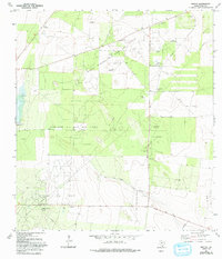
1972 Map of Rincon
USGS Topo · Published 1993About this map
North Rincon Oil and Gas Field and the Cameron Oil and Gas Field dominate this Starr County landscape, illustrating the extensive petroleum infrastructure of South Texas during the early 1970s. The settlement of Rincon sits at the nexus of this industrial activity, supported by a network of pipelines, a Gas Plant, and a Refinery. This survey, field-checked in 1972, reveals how the energy economy reshaped the brush country, with numerous Drill Holes and gravel pits scattered across the terrain.
Find a feature on this map
19 named features on this map. Tap any name to fly to it.
Don’t see what you’re looking for? This feature index may not catch every label — zoom into the map to look around manually.
Map Details
Editions of this 1972 Rincon Map
2 editions found
Other maps of this area

1938 · Sal Colorada
USGS Topo · 1:62,500

1939 · La Reforma
USGS Topo · 1:62,500

1940 · Monte Christo
USGS Topo · 1:62,500

1949 · Mc Allen
USGS Topo · 1:250,000

1954 · McAllen
USGS Topo · 1:250,000

1956 · Garcias
USGS Topo · 1:62,500

1957 · Mc Allen
USGS Topo · 1:250,000

1962 · McAllen
USGS Topo · 1:250,000
1963 · McCook
USGS Topo · 1:24,000
1965 · Camp Garcia
USGS Topo · 1:24,000