
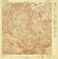
1949 Map of Rio Grande SO
USGS Topo · Published 1949About this map
Coastal sugar cultivation and early municipal development define this northeast Puerto Rico corridor in the late 1940s. The landscape is dominated by the industrial agricultural footprint of the colonias, including Colonia Mimi, Colonia Dolores, and Colonia Blasina, which were essential to the local economy. An intricate network of irrigation and drainage canals, such as Canal Gordiani and Canal Concella, crisscrosses the low-lying Ciénaga Baja near the mouth of the Río Herrera.
Find a feature on this map
40 named features on this map. Tap any name to fly to it.
Don’t see what you’re looking for? This feature index may not catch every label — zoom into the map to look around manually.
Map Details
Editions of this 1949 Rio Grande SO Map
This is the sole edition of this map. No revisions or reprints were ever made.
Other maps of this area

1940 · Carolina
USGS Topo · 1:30,000

1941 · Rio Grande
USGS Topo · 1:30,000

1941 · Carolina
USGS Topo · 1:30,000

1945 · El Yunque
USGS Topo · 1:30,000

1946 · El Yunque
USGS Topo · 1:30,000

1946 · Gurabo
USGS Topo · 1:30,000

1947 · Carolina
USGS Topo · 1:30,000
1947 · El Yunque NE
USGS Topo · 1:10,000
1947 · Gurabo NE
USGS Topo · 1:10,000

1947 · Rio Grande
USGS Topo · 1:30,000
Featured Places
- Río Grande, Río Grande
- Vieques, Loíza
- Pompeya, Loíza
- Herreras, Río Grande
- Miradores del Yunque, Río Grande