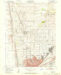
1951 Map of Rio Linda
USGS Topo · Published 1951About this map
McClellan Field and its surrounding military reservation anchor the eastern landscape of this Sacramento County region, reflecting the area's mid-century strategic importance. The northern suburbs show a distinct transition from the dense residential grid of Del Paso Heights and Hagginwood to the more open, agricultural character of Rio Linda and Elverta. Transportation networks are heavily represented by the Southern Pacific and Sacramento Northern railroads, which facilitated local growth alongside the developing Sacramento Freeway.
Find a feature on this map
50 named features on this map. Tap any name to fly to it.
Don’t see what you’re looking for? This feature index may not catch every label — zoom into the map to look around manually.
Map Details
Editions of this 1951 Rio Linda Map
This is the sole edition of this map. No revisions or reprints were ever made.
Other maps of this area

1891 · Sacramento
USGS Topo · 1:125,000

1892 · Sacramento
USGS Topo · 1:125,000

1893 · Sacramento
USGS Topo · 1:125,000

1902 · Fairoaks
USGS Topo · 1:62,500

1907 · Davisville
USGS Topo · 1:62,500

1910 · Roseville
USGS Topo · 1:31,680

1910 · Vernon
USGS Topo · 1:31,680

1910 · Pleasant Grove
USGS Topo · 1:31,680

1911 · Brighton
USGS Topo · 1:31,680

1911 · Mills
USGS Topo · 1:31,680