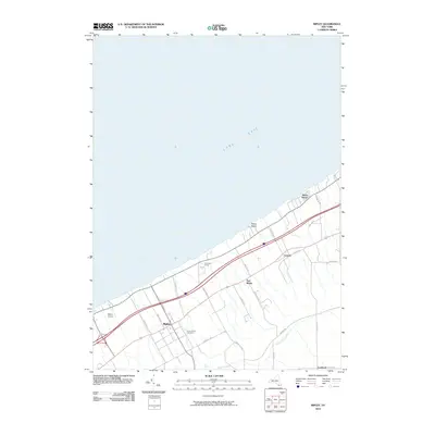
2010 Map of Ripley
USGS Topo · Published 2010About this map
Lake Erie defines the northern edge of this Chautauqua County landscape, where the shoreline is punctuated by small lakeside communities such as Shore Haven and Ripley Beach. Moving inland, the terrain climbs away from the water, shaped by the drainage of Belson Creek and a network of roads that follow the lake's contour. The village of Ripley serves as a central hub, surrounded by smaller settlements like East Ripley, Forsyth, and Lombard near the Pennsylvania border. Genealogical interest is centered on the Quincy Rural Cemetery, while the presence of McIntosh Farms and Ripley Airport highlights the mix of agricultural tradition and modern infrastructure. This 2010 survey illustrates the corridor's development along Old Rte 20, where transport routes and small-scale settlements cluster between the lake and the rising hills to the south.
Find a feature on this map
28 named features on this map. Tap any name to fly to it.
Don’t see what you’re looking for? This feature index may not catch every label — zoom into the map to look around manually.
Map Details
Editions of this 2010 Ripley Map
This is the sole edition of this map. No revisions or reprints were ever made.
Other maps of this area

1899 · Westfield
USGS Topo · 1:62,500

1905 · Clymer
USGS Topo · 1:62,500

1913 · North East
USGS Topo · 1:62,500

1915 · North East
USGS Topo · 1:62,500

1939 · Clymer
USGS Topo · 1:62,500

1941 · Clymer
USGS Topo · 1:62,500

1943 · North East
USGS Topo · 1:62,500

1954 · South Ripley
USGS Topo · 1:24,000

1954 · Ripley
USGS Topo · 1:24,000
1954 · Sherman
USGS Topo · 1:24,000