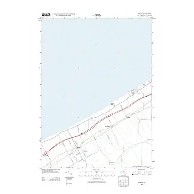
2013 Map of Ripley
USGS Topo · Published 2013About this map
Lake Erie defines the northern edge of this Chautauqua County landscape, where the shoreline alternates between the open sands of Ripley Beach and the developed communities of Shore Haven and McIntosh Farms. This region in the early 21st century remains anchored by the settlement of Ripley, where the local Po and Quincy Rural Cem serve as historical and community anchors. The map illustrates a dense network of local roads and thoroughfares like Old Route 20 that run parallel to the lake, connecting smaller hamlets such as East Ripley and Forsyth. Further inland, the terrain transitions to more agricultural and rural uses near Lombard, with Belson Cr cutting through the southern reaches. Genealogists and local historians will find value in the precise locations of burial grounds like the E Ripley Cem, situated just off the main transit corridors that have shaped the development of this lakeside district.
Find a feature on this map
47 named features on this map. Tap any name to fly to it.
Don’t see what you’re looking for? This feature index may not catch every label — zoom into the map to look around manually.
Map Details
Editions of this 2013 Ripley Map
This is the sole edition of this map. No revisions or reprints were ever made.
Other maps of this area

1899 · Westfield
USGS Topo · 1:62,500

1905 · Clymer
USGS Topo · 1:62,500

1913 · North East
USGS Topo · 1:62,500

1915 · North East
USGS Topo · 1:62,500

1939 · Clymer
USGS Topo · 1:62,500

1941 · Clymer
USGS Topo · 1:62,500

1943 · North East
USGS Topo · 1:62,500

1954 · South Ripley
USGS Topo · 1:24,000

1954 · Ripley
USGS Topo · 1:24,000
1954 · Sherman
USGS Topo · 1:24,000