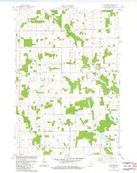
1981 Map of Riplinger
USGS Topo · Published 1982About this map
Dairy country in Clark County is defined by a dense network of country roads and family-centered landmarks in this early 1980s study. The village of Riplinger sits at the junction of Riplinger Road and Popple River Road, serving as a central hub for the surrounding townships of Green Grove, Colby, and Unity. The landscape is a mix of woodlots and drainage basins, with the South Fork Popple River and Nelson Creek carving through the northern sections while the Yellow River and Rock Creek navigate the southern reaches.
Find a feature on this map
31 named features on this map. Tap any name to fly to it.
Don’t see what you’re looking for? This feature index may not catch every label — zoom into the map to look around manually.
Map Details
Editions of this 1981 Riplinger Map
This is the sole edition of this map. No revisions or reprints were ever made.
Other maps of this area

1953 · Neillsville
USGS Topo · 1:62,500

1953 · Abbotsford
USGS Topo · 1:48,000

1953 · Owen
USGS Topo · 1:48,000

1953 · Eau Claire
USGS Topo · 1:250,000

1954 · Granton
USGS Topo · 1:62,500

1958 · Eau Claire
USGS Topo · 1:250,000

1963 · Abbotsford
USGS Topo · 1:62,500

1963 · Owen
USGS Topo · 1:62,500

1964 · Eau Claire
USGS Topo · 1:250,000
1979 · Loyal East
USGS Topo · 1:24,000