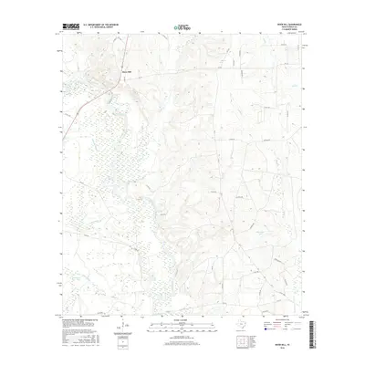
2016 Map of River Hill
USGS Topo · Published 2016About this map
River Hill sits at the northern end of this Panola County landscape, where the Sabine River carves a complex course through a dense network of bottomland waterways. The terrain is defined by its extensive slough and bayou systems, including the long reach of Fish Lake Slough and the winding Hoggs Bayou. These wetland features, alongside Dark Slough and Hill Lake, reveal the shifting hydrology of the river basin over time. Away from the river banks, the map indicates the local economic footprint with several named infrastructure points like Oil Well Rd and Oilfield Rd. In the eastern portion of the quadrangle, Alexander Lake and the drainage of Socagee Cr provide further detail for those tracing the historical geography of this East Texas border region.
Find a feature on this map
42 named features on this map. Tap any name to fly to it.
Don’t see what you’re looking for? This feature index may not catch every label — zoom into the map to look around manually.
Map Details
Editions of this 2016 River Hill Map
This is the sole edition of this map. No revisions or reprints were ever made.
Other maps of this area

1943 · Waskom
USGS Topo · 1:62,500

1945 · Waskom
USGS Topo · 1:62,500

1945 · Socagee Bayou
USGS Topo · 1:62,500

1956 · Tyler
USGS Topo · 1:250,000

1956 · Deadwood
USGS Topo · 1:62,500

1958 · Darco
USGS Topo · 1:62,500

1958 · Carthage
USGS Topo · 1:62,500

1962 · De Berry
USGS Topo · 1:24,000
1962 · Panola
USGS Topo · 1:24,000

1983 · Grand Bluff
USGS Topo · 1:24,000