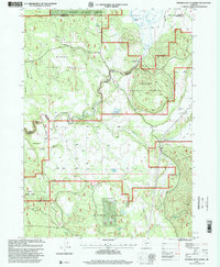
1998 Map of Riverbed Butte Spring
USGS Topo · Published 2000About this map
Fremont National Forest and Winema National Forest dominate this high-altitude landscape along the border of Lake and Klamath Counties. The Sycan River meanders through the northeast corner, feeding into Marsh Reservoir, while the surrounding terrain is defined by volcanic features and essential water sources. Forest management infrastructure is prominent, including the Sycan Fire Guard Station and the Black Hills Guard Station, which served as critical points for wilderness monitoring and logistics during the late 20th century.
Find a feature on this map
17 named features on this map. Tap any name to fly to it.
Don’t see what you’re looking for? This feature index may not catch every label — zoom into the map to look around manually.
Map Details
Editions of this 1998 Riverbed Butte Spring Map
This is the sole edition of this map. No revisions or reprints were ever made.
Other maps of this area

1889 · Klamath
USGS Topo · 1:250,000

1894 · Klamath
USGS Topo · 1:250,000

1955 · Klamath Falls
USGS Topo · 1:250,000

1958 · Klamath Falls
USGS Topo · 1:250,000

1960 · Riverbed Butte
USGS Topo · 1:62,500

1960 · Sycan Marsh
USGS Topo · 1:62,500

1960 · Fuego Mountain
USGS Topo · 1:62,500

1960 · Yamsay Mountain
USGS Topo · 1:62,500

1980 · Williamson River
USGS Topo · 1:100,000
1988 · Sycan Marsh West
USGS Topo · 1:24,000