
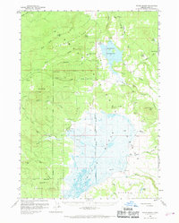
1960 Map of Sycan Marsh
USGS Topo · Published 1961About this map
Sycan Marsh dominates the southern half of this landscape, its complex wetlands and river channels feeding into the Sycan River. This 1960 survey documents a high-altitude basin where the Fremont National Forest meets active cattle ranching and timber extraction. The presence of the Logging Railroad winding through the eastern hills toward Sycan Butte highlights the industrial character of the era, while the Old Indian Reservation Boundary cuts a historical line across the western reaches near Indian Creek Flat. In the north, Thompson Reservoir appears as a major water body, surrounded by smaller landmarks like Elder Cabin and the Ginder Pit. Settlement is sparse but permanent, represented by established operations such as the Z X Ranch, Carlon Ranch, and Bratton Ranch, along with the former Camp Fifteen (Site).
Find a feature on this map
53 named features on this map. Tap any name to fly to it.
Don’t see what you’re looking for? This feature index may not catch every label — zoom into the map to look around manually.
Map Details
Editions of this 1960 Sycan Marsh Map
2 editions found
Other maps of this area

1889 · Klamath
USGS Topo · 1:250,000

1894 · Klamath
USGS Topo · 1:250,000

1955 · Crescent
USGS Topo · 1:250,000

1955 · Klamath Falls
USGS Topo · 1:250,000

1957 · Crescent
USGS Topo · 1:250,000

1958 · Crescent
USGS Topo · 1:250,000

1958 · Klamath Falls
USGS Topo · 1:250,000

1960 · Riverbed Butte
USGS Topo · 1:62,500

1960 · Fuego Mountain
USGS Topo · 1:62,500

1960 · Yamsay Mountain
USGS Topo · 1:62,500