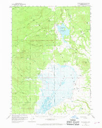
1960 Map of Sycan Marsh
USGS Topo · Published 1969About this map
Sycan Marsh dominates the southern half of this Oregon landscape, a seasonal wetland complex where the Sycan River and Shake Creek converge within the Fremont National Forest. This 1960s-era survey documents the high-desert timber and ranching economy, centered on the Logging Railroad spurs that once reached deep into the drainage to extract ponderosa pine. Remote habitations such as the Z X Ranch, Bratton Ranch, and Carlon Ranch mark the edges of the marshland, while the former Camp Fifteen (Site) points to earlier industrial activity. The northern section is defined by the Thompson Reservoir and rugged volcanic features like Alder Spring Ridge and Partin Butte. Historical boundaries are clearly preserved here, including the Old Indian Reservation Boundary, which cuts across the marsh and ridges, signifying the complex land-use history of Lake County.
Find a feature on this map
47 named features on this map. Tap any name to fly to it.
Don’t see what you’re looking for? This feature index may not catch every label — zoom into the map to look around manually.
Map Details
Editions of this 1960 Sycan Marsh Map
2 editions found
Other maps of this area

1889 · Klamath
USGS Topo · 1:250,000

1894 · Klamath
USGS Topo · 1:250,000

1955 · Crescent
USGS Topo · 1:250,000

1955 · Klamath Falls
USGS Topo · 1:250,000

1957 · Crescent
USGS Topo · 1:250,000

1958 · Crescent
USGS Topo · 1:250,000

1958 · Klamath Falls
USGS Topo · 1:250,000

1960 · Riverbed Butte
USGS Topo · 1:62,500

1960 · Sycan Marsh
USGS Topo · 1:62,500

1960 · Fuego Mountain
USGS Topo · 1:62,500