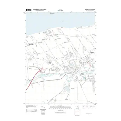
2013 Map of Riverhead
USGS Topo · Published 2013About this map
Peconic River frontage and the northern shores of Long Island Sound define this landscape on the eastern end of Long Island. The map shows a transition from established agricultural roots, represented by Briermere Farms and Edward Zilnicki Farms, to modern recreation and conservation areas like the Cherry Creek Golf Links and The Preserve. The central hub of Riverhead is flanked by residential developments such as Foxwood Village and Lakewood Park, while the historic Long Island Railroad corridor continues to influence the layout of settlements like Calverton. Genealogical interest is found in well-marked burial grounds including Riverhead Cem and Saint Johns Cem. Along the northern coast, the elevation shifts at Friars Head and Roanoke Point, providing a topographical contrast to the low-lying wetlands and ponds like Wildwood Lake and Sweezey Pond further south.
Find a feature on this map
227 named features on this map. Tap any name to fly to it.
Don’t see what you’re looking for? This feature index may not catch every label — zoom into the map to look around manually.
Map Details
Editions of this 2013 Riverhead Map
This is the sole edition of this map. No revisions or reprints were ever made.
Other maps of this area

1903 · Riverhead
USGS Topo · 1:62,500

1904 · Riverhead
USGS Topo · 1:62,500

1904 · Moriches
USGS Topo · 1:62,500

1943 · Riverhead
USGS Topo · 1:62,500

1947 · Mattituck
USGS Topo · 1:24,000

1947 · Mattituck Hills
USGS Topo · 1:24,000

1947 · Riverhead
USGS Topo · 1:24,000

1947 · Quogue
USGS Topo · 1:24,000

1947 · Eastport
USGS Topo · 1:24,000

1947 · Hartford
USGS Topo · 1:250,000