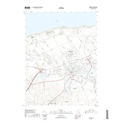
2019 Map of Riverhead
USGS Topo · Published 2019About this map
Riverhead stands as the primary hub of activity in this part of Suffolk County, situated at the mouth of the Peconic River where it meets the wetlands of the Peconic Bay system. The landscape transition from the north shore beaches at Roanoke Point on the Long Island Sound to the interior glacial moraine features like Bald Hill is clearly visible. The area serves as a significant administrative center, housing the Suffolk County Courthouse and the Honorable Alan D Oshrin Supreme Court Building. Beyond the municipal core, the map detail encompasses diverse water bodies including Peconic Lake, Swan Pond, and Sweezy Pond, which have long defined the geography of the surrounding hamlets of Riverside and Northampton. Significant academic footprints are present through the Suffolk County Community College Eastern Campus and Long Island University Riverhead, while historical burial grounds like the Baiting Hollow Cem and Saint John the Evangelist Cem provide anchor points for genealogical research.
Find a feature on this map
38 named features on this map. Tap any name to fly to it.
Don’t see what you’re looking for? This feature index may not catch every label — zoom into the map to look around manually.
Map Details
Editions of this 2019 Riverhead Map
This is the sole edition of this map. No revisions or reprints were ever made.
Other maps of this area

1903 · Riverhead
USGS Topo · 1:62,500

1904 · Riverhead
USGS Topo · 1:62,500

1904 · Moriches
USGS Topo · 1:62,500

1943 · Riverhead
USGS Topo · 1:62,500

1947 · Mattituck
USGS Topo · 1:24,000

1947 · Mattituck Hills
USGS Topo · 1:24,000

1947 · Riverhead
USGS Topo · 1:24,000

1947 · Quogue
USGS Topo · 1:24,000

1947 · Eastport
USGS Topo · 1:24,000

1947 · Hartford
USGS Topo · 1:250,000