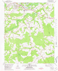
1980 Map of Rivermont
USGS Topo · Published 1981About this map
The Neuse River serves as a dominant northern boundary for this area of Lenoir County, where the southern outskirts of Kinston meet the expansive lowlands of Ball Pocosin. The landscape is a network of slow-moving water, defined by the winding paths of Southwest Creek, Mott Swamp, and Vine Swamp. The settlement pattern follows the higher ground between these drainages, with the Atlantic and North Carolina railroad corridor linking the eastern village of Caswell toward the larger hub of Kinston.
Find a feature on this map
51 named features on this map. Tap any name to fly to it.
Don’t see what you’re looking for? This feature index may not catch every label — zoom into the map to look around manually.
Map Details
Editions of this 1980 Rivermont Map
This is the sole edition of this map. No revisions or reprints were ever made.
Other maps of this area

1902 · Ayden
USGS Topo · 1:62,500

1903 · Trent River
USGS Topo · 1:62,500

1904 · Ayden
USGS Topo · 1:62,500

1904 · Trent River
USGS Topo · 1:62,500

1914 · Kinston
USGS Topo · 1:48,000

1916 · Kinston
USGS Topo · 1:62,500

1953 · Rocky Mount
USGS Topo · 1:250,000

1954 · Rocky Mount
USGS Topo · 1:250,000

1958 · Deep Run
USGS Topo · 1:62,500
1980 · Pink Hill
USGS Topo · 1:24,000