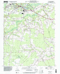
1998 Map of Rivermont
USGS Topo · Published 2001About this map
The Neuse River defines the northern reaches of this coastal plain landscape, where the urban edge of Kinston transitions into a network of agricultural communities and swampy lowlands. As mapped in the late 1990s, the area south of the river is characterized by several crossroads settlements like Southwood and Loftins Crossroads, connected by a web of rural routes. The map is particularly rich in ecclesiastical and educational landmarks, featuring Lenoir Community College and numerous local congregations such as Kings Chapel, St Paul Ch, and Patterson Chapel.
Find a feature on this map
46 named features on this map. Tap any name to fly to it.
Don’t see what you’re looking for? This feature index may not catch every label — zoom into the map to look around manually.
Map Details
Editions of this 1998 Rivermont Map
This is the sole edition of this map. No revisions or reprints were ever made.
Other maps of this area

1902 · Ayden
USGS Topo · 1:62,500

1903 · Trent River
USGS Topo · 1:62,500

1904 · Ayden
USGS Topo · 1:62,500

1904 · Trent River
USGS Topo · 1:62,500

1914 · Kinston
USGS Topo · 1:48,000

1916 · Kinston
USGS Topo · 1:62,500

1953 · Rocky Mount
USGS Topo · 1:250,000

1954 · Rocky Mount
USGS Topo · 1:250,000

1958 · Deep Run
USGS Topo · 1:62,500
1980 · Pink Hill
USGS Topo · 1:24,000