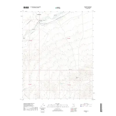
2018 Map of Riverside
USGS Topo · Published 2018About this map
Riverside sits at the edge of the Virgin Valley in this desert study, where the Virgin River creates a corridor of fertile lowlands including Arnold Bottom, Latham Bottom, and Cook Bottom. The terrain is defined by the sharp transition from these river bottoms to the elevated reaches of Bunkerville Ridge and the Mojave Desert. Water remains the primary shaper of human and natural activity here, as seen in the location of Juanita Springs, Government Spring, and North Key West Spring. Modern recreation routes like Bikepacking: The Plateau Passage follow the high ground, while the River Cliff Rd and New Gold Butte Rd provide access through the complex network of drainages such as Nickel Cr.
Find a feature on this map
20 named features on this map. Tap any name to fly to it.
Don’t see what you’re looking for? This feature index may not catch every label — zoom into the map to look around manually.
Map Details
Editions of this 2018 Riverside Map
This is the sole edition of this map. No revisions or reprints were ever made.
Other maps of this area

1886 · Saint Thomas
USGS Topo · 1:250,000

1893 · Saint Thomas
USGS Topo · 1:250,000

1954 · Las Vegas
USGS Topo · 1:250,000

1957 · Las Vegas
USGS Topo · 1:250,000

1957 · Mesquite
USGS Topo · 1:62,500

1958 · Virgin Peak
USGS Topo · 1:62,500

1958 · Overton
USGS Topo · 1:62,500

1959 · Las Vegas
USGS Topo · 1:250,000

1962 · Las Vegas
USGS Topo · 1:250,000
1969 · Moapa Peak SE
USGS Topo · 1:24,000