
1958 Map of Virgin Peak
USGS Topo · Published 1960About this map
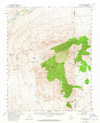
The Virgin Mountains dominate this landscape where Nevada meets Arizona, anchored by the high elevation of Virgin Peak. This late 1950s survey shows a remote desert environment punctuated by small-scale ranching and mineral exploration. Isolated outposts like Juanita Springs Ranch, Whitney Ranch, and Jacobs Ranch appear near vital water sources such as Hees Hole Spring and Red Rock Spring. The presence of Petroglyphs near Whitney Pocket Water points to the deep indigenous history of the region before the arrival of the mining interests seen at the Great Western Mine and Nickel Mine. Movement through this arid terrain relied on the New Gold Butte Road and the Pakoon Springs Road, which linked the high peaks to the lowlands of Hungry Valley and the banks of the Virgin River at Riverside.
Find a feature on this map
44 named features on this map. Tap any name to fly to it.
Don’t see what you’re looking for? This feature index may not catch every label — zoom into the map to look around manually.
Map Details
Editions of this 1958 Virgin Peak Map
2 editions found
Other maps of this area

1886 · Saint Thomas
USGS Topo · 1:250,000

1886 · Mt. Trumbull
USGS Topo · 1:250,000

1892 · Mt. Trumbull
USGS Topo · 1:250,000

1893 · Saint Thomas
USGS Topo · 1:250,000

1926 · Bonelli
USGS Topo · 1:96,000

1953 · Overton Beach
USGS Topo · 1:62,500

1953 · Gold Butte
USGS Topo · 1:62,500

1953 · Grand Canyon
USGS Topo · 1:250,000

1954 · Las Vegas
USGS Topo · 1:250,000

1954 · Littlefield 3 SW
USGS Topo · 1:24,000