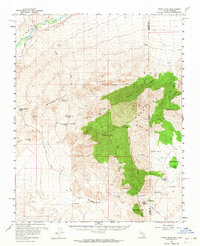
1958 Map of Virgin Peak
USGS Topo · Published 1964About this map
Virgin River waters carve through the northwest corner of this desert landscape, where the settlements of Riverside and Juanita Springs Ranch sit against the backdrop of the Virgin Mountains. This 1950s era survey documents a transition from early ranching and mining to modern accessibility, tracing the New Gold Butte Road as it winds through Black Ridge toward the high peaks. The map reveals a history of extraction at the Great Eastern Mine and North Key West Mine, while providing evidence of even earlier inhabitants with the recorded location of Petroglyphs near the south end of the ridge. Water sources like Whitney Pocket and Cabin Spring appear as critical survival points in this arid terrain, marking the landscape for those navigating the routes between the Bunkerville Ridge and the South Virgin Peak Ridge.
Find a feature on this map
48 named features on this map. Tap any name to fly to it.
Don’t see what you’re looking for? This feature index may not catch every label — zoom into the map to look around manually.
Map Details
Editions of this 1958 Virgin Peak Map
2 editions found

Other maps of this area

1886 · Saint Thomas
USGS Topo · 1:250,000

1886 · Mt. Trumbull
USGS Topo · 1:250,000

1892 · Mt. Trumbull
USGS Topo · 1:250,000

1893 · Saint Thomas
USGS Topo · 1:250,000

1926 · Bonelli
USGS Topo · 1:96,000

1953 · Overton Beach
USGS Topo · 1:62,500

1953 · Gold Butte
USGS Topo · 1:62,500

1953 · Grand Canyon
USGS Topo · 1:250,000

1954 · Las Vegas
USGS Topo · 1:250,000

1954 · Littlefield 3 SW
USGS Topo · 1:24,000