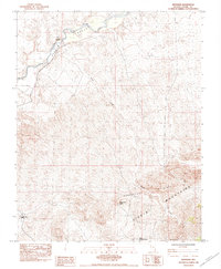
1983 Map of Riverside
USGS Topo · Published 1984About this map
Virgin Valley dominates the northern reaches of this map, where the Virgin River carves its path toward the settlement of Riverside. This 1982 field-checked survey highlights the sharp contrast between the riverine corridor and the formidable desert highlands to the south. The terrain ascends dramatically into Bunkerville Ridge and the Virgin Mountains, a landscape defined by deep drainage systems like Nickel Creek.
Find a feature on this map
11 named features on this map. Tap any name to fly to it.
Don’t see what you’re looking for? This feature index may not catch every label — zoom into the map to look around manually.
Map Details
Editions of this 1983 Riverside Map
This is the sole edition of this map. No revisions or reprints were ever made.
Other maps of this area

1886 · Saint Thomas
USGS Topo · 1:250,000

1893 · Saint Thomas
USGS Topo · 1:250,000

1954 · Las Vegas
USGS Topo · 1:250,000

1957 · Las Vegas
USGS Topo · 1:250,000

1957 · Mesquite
USGS Topo · 1:62,500

1958 · Virgin Peak
USGS Topo · 1:62,500

1958 · Overton
USGS Topo · 1:62,500

1959 · Las Vegas
USGS Topo · 1:250,000

1962 · Las Vegas
USGS Topo · 1:250,000
1969 · Moapa Peak SE
USGS Topo · 1:24,000