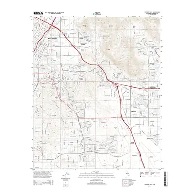
2015 Map of Riverside East
USGS Topo · Published 2015About this map
Riverside and its eastern suburbs are defined by a complex intersection of academic, military, and water infrastructure. The campus of the University of California Riverside anchors the northern residential districts like Bannockburn Village and Canyon Crest Heights, while the sprawling grounds of March Field and the March Air Reserve Base dominate the southeastern landscape. This area serves as a critical corridor for Southern California water management, evidenced by the presence of the Gage Canal, the Riverside Canal, and the Governor Edmund G Brown Jr California Aqueduct. The high desert terrain of the Box Springs Mountains and Sycamore Canyon creates natural boundaries between established neighborhoods and the growing communities of Edgemont and Sunnymead.
Find a feature on this map
38 named features on this map. Tap any name to fly to it.
Don’t see what you’re looking for? This feature index may not catch every label — zoom into the map to look around manually.
Map Details
Editions of this 2015 Riverside East Map
This is the sole edition of this map. No revisions or reprints were ever made.
Other maps of this area

1896 · San Bernardino
USGS Topo · 1:62,500

1898 · San Bernardino
USGS Topo · 1:62,500

1899 · Redlands
USGS Topo · 1:62,500

1901 · Southern California Sheet No. 1
USGS Topo · 1:250,000

1901 · San Bernardino
USGS Topo · 1:62,500

1901 · Redlands
USGS Topo · 1:62,500

1901 · Elsinore
USGS Topo · 1:125,000

1901 · Riverside
USGS Topo · 1:62,500

1904 · Southern California Sheet No. 1
USGS Topo · 1:250,000
1938 · Colton
USGS Topo · 1:31,680