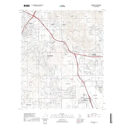
2018 Map of Riverside East
USGS Topo · Published 2018About this map
Riverside National Cemetery and the sprawling military installation at March AFB anchor the southern landscape of this 2018 survey. The map records the complex suburban and institutional development of eastern Riverside and Moreno Valley, where residential neighborhoods like Canyon Crest Heights and Edgemont meet the steep slopes of the Box Springs Mountains. Historic water infrastructure, including the Gage Canal and Riverside Canal, remains visible alongside modern transport corridors like the At&Sf Rr. Higher elevations to the north and east, such as Sugarloaf Mtn and Pigeon Pass, provide a sharp contrast to the dense network of streets serving the Univ of California Riverside. This edition documents the intensive land use of the Inland Empire, from the flight lines of March Air Reserve Base to the protected open spaces of Sycamore Canyon.
Find a feature on this map
51 named features on this map. Tap any name to fly to it.
Don’t see what you’re looking for? This feature index may not catch every label — zoom into the map to look around manually.
Map Details
Editions of this 2018 Riverside East Map
This is the sole edition of this map. No revisions or reprints were ever made.
Other maps of this area

1896 · San Bernardino
USGS Topo · 1:62,500

1898 · San Bernardino
USGS Topo · 1:62,500

1899 · Redlands
USGS Topo · 1:62,500

1901 · Southern California Sheet No. 1
USGS Topo · 1:250,000

1901 · San Bernardino
USGS Topo · 1:62,500

1901 · Redlands
USGS Topo · 1:62,500

1901 · Elsinore
USGS Topo · 1:125,000

1901 · Riverside
USGS Topo · 1:62,500

1904 · Southern California Sheet No. 1
USGS Topo · 1:250,000
1938 · Colton
USGS Topo · 1:31,680