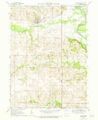
1969 Map of Riverside
USGS Topo · Published 1971About this map
Riverside serves as the focal point of this late 1960s Iowa landscape, situated at the confluence of the English River and the Chicago Rock Island and Pacific railroad line. The settlement's infrastructure includes the Mt Olivet Ch and a central Sewage Disposal plant, reflecting a period of mid-century civic development. Beyond the town limits, the topography is defined by the winding paths of Davis Creek and Goose Creek, which carve through the townships of Jackson and Highland. For genealogists, the map is particularly detailed, identifying several rural burial grounds such as St Vincent Cem, Locust Grove Cem, and Harrisburg Cem. The inclusion of the Highland Sch to the south illustrates the enduring presence of rural school districts even as regional consolidation was reshaping the American educational landscape.
Find a feature on this map
18 named features on this map. Tap any name to fly to it.
Don’t see what you’re looking for? This feature index may not catch every label — zoom into the map to look around manually.
Map Details
Editions of this 1969 Riverside Map
2 editions found
Other maps of this area

1891 · Iowa City
USGS Topo · 1:62,500

1894 · West Liberty
USGS Topo · 1:62,500

1901 · Stanwood
USGS Topo · 1:125,000

1903 · Fairfax
USGS Topo · 1:125,000

1938 · Iowa City
USGS Topo · 1:62,500

1958 · Davenport
USGS Topo · 1:250,000

1961 · Davenport
USGS Topo · 1:250,000

1962 · Davenport
USGS Topo · 1:250,000

1965 · Williamstown
USGS Topo · 1:24,000
1965 · West Liberty SW
USGS Topo · 1:24,000