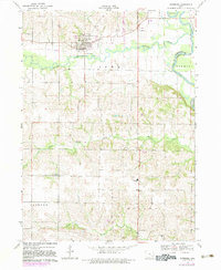
1969 Map of Riverside
USGS Topo · Published 1983About this map
The English River meanders through the northern portion of this map, defining the landscape near the town of Riverside. This area, updated with photographic revisions into the early 1980s, reveals a rural landscape deeply rooted in family and community history. Genealogists will find a high density of burial grounds including St Vincent Cem, Mt Olivet Cem, Riverside Cem, and the more isolated Locust Grove Cem and Harrisburg Cem. These sites, along with the Highland Sch, reflect the established social structure of Washington Co and Johnson Co at the time. The terrain is characterized by the drainage basins of Davis Creek and Goose Creek, where the land transitions from river bottom to the textured ridges of Highland and Jackson townships.
Find a feature on this map
16 named features on this map. Tap any name to fly to it.
Don’t see what you’re looking for? This feature index may not catch every label — zoom into the map to look around manually.
Map Details
Editions of this 1969 Riverside Map
2 editions found
Other maps of this area

1891 · Iowa City
USGS Topo · 1:62,500

1894 · West Liberty
USGS Topo · 1:62,500

1901 · Stanwood
USGS Topo · 1:125,000

1903 · Fairfax
USGS Topo · 1:125,000

1938 · Iowa City
USGS Topo · 1:62,500

1958 · Davenport
USGS Topo · 1:250,000

1961 · Davenport
USGS Topo · 1:250,000

1962 · Davenport
USGS Topo · 1:250,000

1965 · Williamstown
USGS Topo · 1:24,000
1965 · West Liberty SW
USGS Topo · 1:24,000