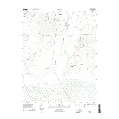
2016 Map of Rives
USGS Topo · Published 2016About this map
The North Fork Obion River and the Rutherford Fork Obion River converge in this western Tennessee landscape, creating an intricate network of wetlands and oxbow lakes. Small settlements including Rives, Troy, and Moffatt serve as the primary nodes for a rural road system that follows the high ground between the river bottoms. The topography is defined by the broad, marshy basins of the Obion River system, where features like Horseshoe Lake, Long Lake, and Big Lake indicate the shifting course of the water over time.
Find a feature on this map
76 named features on this map. Tap any name to fly to it.
Don’t see what you’re looking for? This feature index may not catch every label — zoom into the map to look around manually.
Map Details
Editions of this 2016 Rives Map
This is the sole edition of this map. No revisions or reprints were ever made.
Other maps of this area

1950 · Obion
USGS Topo · 1:24,000

1950 · Rives
USGS Topo · 1:24,000

1951 · Obion
USGS Topo · 1:24,000

1951 · Rives
USGS Topo · 1:24,000

1954 · Rutherford
USGS Topo · 1:24,000

1954 · Union City
USGS Topo · 1:24,000

1956 · Gardner
USGS Topo · 1:24,000

1956 · Harris
USGS Topo · 1:24,000

1956 · Dyersburg
USGS Topo · 1:250,000
1965 · Kenton
USGS Topo · 1:24,000