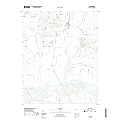
2019 Map of Rives
USGS Topo · Published 2019About this map
Rives and McCutchen Heights occupy the center-stage of this Obion County landscape, situated where the North Fork Obion River begins its wide, meandering course through a system of wetlands and bottomlands. To the west, the settlement of Troy is connected by Pleasant Hill Rd, which passes several early burial grounds including Pleasant Hill Cem and West Hill Cem. The geography is defined by a dense network of water bodies such as Botts Lake and Turner Lake, which populate the uplands above the river valley.
Find a feature on this map
74 named features on this map. Tap any name to fly to it.
Don’t see what you’re looking for? This feature index may not catch every label — zoom into the map to look around manually.
Map Details
Editions of this 2019 Rives Map
This is the sole edition of this map. No revisions or reprints were ever made.
Other maps of this area

1950 · Obion
USGS Topo · 1:24,000

1950 · Rives
USGS Topo · 1:24,000

1951 · Obion
USGS Topo · 1:24,000

1951 · Rives
USGS Topo · 1:24,000

1954 · Rutherford
USGS Topo · 1:24,000

1954 · Union City
USGS Topo · 1:24,000

1956 · Gardner
USGS Topo · 1:24,000

1956 · Harris
USGS Topo · 1:24,000

1956 · Dyersburg
USGS Topo · 1:250,000
1965 · Kenton
USGS Topo · 1:24,000