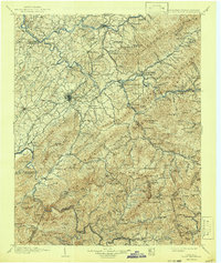
1904 Map of Roan Mountain
USGS Topo · Published 1942About this map
Roan Mountain dominates this rugged borderland between Tennessee and North Carolina, where the peaks of the Unaka Mountains and Iron Mountains intersect. At the turn of the century, the region was defined by a complex network of river crossings and emerging railroads. Ferries and fords provided critical passage over the Holston River and Watauga River, notably at Yoakley Ferry and Spurgeon Ford. Industrial footprints are visible through the Hodge Ore Bank and the winding routes of several carriers, including the East Tennessee and Western North Carolina RR and the Watauga and Southwestern RR.
Find a feature on this map
180 named features on this map. Tap any name to fly to it.
Don’t see what you’re looking for? This feature index may not catch every label — zoom into the map to look around manually.
Map Details
Editions of this 1904 Roan Mountain Map
4 editions found

Other maps of this area

1891 · Roan Mountain
USGS Topo · 1:125,000

1891 · Abingdon
USGS Topo · 1:125,000

1892 · Greeneville
USGS Topo · 1:125,000

1893 · Cranberry
USGS Topo · 1:125,000

1894 · Asheville
USGS Topo · 1:125,000

1894 · Roan Mountain
USGS Topo · 1:125,000

1894 · Abingdon
USGS Topo · 1:125,000

1894 · Estillville
USGS Topo · 1:125,000

1895 · Cranberry
USGS Topo · 1:125,000

1896 · Greeneville
USGS Topo · 1:125,000