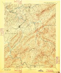
1894 Map of Roan Mountain
USGS Topo · Published 1901About this map
The Tennessee North Carolina Boundary Line snakes through the high country in this late-19th-century survey, dividing the peaks of the Unaka Mountains and Stone Mountain. This era is defined by the deep river valleys of the Watauga River and Nolichucky River, where vital crossings like Shipley Ferry and Yoakley Ferry served local commerce before the proliferation of modern bridges. The rail network of the East Tennessee Virginia and Georgia Railroad connects the industrial hubs of Johnson and Elizabethton, while the Charleston Cincinnati and Chicago Railroad follows the rugged course of the Doe River. Genealogists may find interest in the numerous named fords and mills, such as Bowman Mill and Spurgeon Ford, which mark the early settlement patterns of Sullivan and Carter counties. High-altitude landmarks like Roan High Knob and the Cloudland settlement highlight the elevation changes of this Appalachian landscape.
Find a feature on this map
79 named features on this map. Tap any name to fly to it.
Don’t see what you’re looking for? This feature index may not catch every label — zoom into the map to look around manually.
Map Details
Editions of this 1894 Roan Mountain Map
3 editions found
Other maps of this area

1891 · Roan Mountain
USGS Topo · 1:125,000

1891 · Abingdon
USGS Topo · 1:125,000

1892 · Greeneville
USGS Topo · 1:125,000

1893 · Cranberry
USGS Topo · 1:125,000

1894 · Asheville
USGS Topo · 1:125,000

1894 · Roan Mountain
USGS Topo · 1:125,000

1894 · Abingdon
USGS Topo · 1:125,000

1894 · Estillville
USGS Topo · 1:125,000

1895 · Cranberry
USGS Topo · 1:125,000

1896 · Greeneville
USGS Topo · 1:125,000