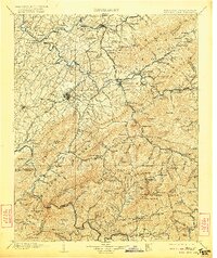
1904 Map of Roan Mountain
USGS Topo · Published 1922About this map
Roan Mountain and the Unaka Mountains dominate the borderlands between Tennessee and North Carolina in this early twentieth-century survey. The high-elevation terrain is defined by the Unaka National Forest and Cherokee National Forest, with Roan High Knob and Roan High Bluff standing as prominent landmarks. Along the valley corridors, the Southern Ry and the East Tennessee and Western North Carolina RR connect growing regional hubs like Johnson City and Erwin to smaller mountain communities.
Find a feature on this map
162 named features on this map. Tap any name to fly to it.
Don’t see what you’re looking for? This feature index may not catch every label — zoom into the map to look around manually.
Map Details
Editions of this 1904 Roan Mountain Map
4 editions found

Other maps of this area

1891 · Roan Mountain
USGS Topo · 1:125,000

1891 · Abingdon
USGS Topo · 1:125,000

1892 · Greeneville
USGS Topo · 1:125,000

1893 · Cranberry
USGS Topo · 1:125,000

1894 · Asheville
USGS Topo · 1:125,000

1894 · Roan Mountain
USGS Topo · 1:125,000

1894 · Abingdon
USGS Topo · 1:125,000

1894 · Estillville
USGS Topo · 1:125,000

1895 · Cranberry
USGS Topo · 1:125,000

1896 · Greeneville
USGS Topo · 1:125,000