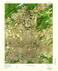
1962 Map of Roanoke
USGS Topo · Published 1962About this map
Roanoke serves as the hub of this experimental 1962 orthophotographic mosaic, which uses aerial photography to show the city's mid-century expansion into the surrounding valley. The dense urban center and residential blocks are clearly visible, bounded to the south by the winding Roanoke River and to the north by the campus of Hollins College. This specific edition was produced to test new mapping techniques, resulting in a unique visual that combines photographic detail with traditional topographic labels. The transportation infrastructure of the era is prominent, featuring the Norfolk and Western rail lines and the Municipal Airport. Surrounding settlements like Vinton, Hollins, and Cloverdale appear in their pre-interstate configurations. The landscape is defined by its waterways, including Tinker Creek and Glade Creek, and the looming presence of Brushy Mountain and Coyner Mtn along the valley edges.
Find a feature on this map
23 named features on this map. Tap any name to fly to it.
Don’t see what you’re looking for? This feature index may not catch every label — zoom into the map to look around manually.
Map Details
Editions of this 1962 Roanoke Map
This is the sole edition of this map. No revisions or reprints were ever made.
Other maps of this area

1890 · Roanoke
USGS Topo · 1:125,000

1890 · Christiansburg
USGS Topo · 1:125,000

1891 · Roanoke
USGS Topo · 1:125,000

1929 · Roanoke
USGS Topo · 1:48,000

1929 · Salem
USGS Topo · 1:48,000

1932 · Salem
USGS Topo · 1:62,500

1933 · Roanoke
USGS Topo · 1:62,500

1947 · Roanoke
USGS Topo · 1:250,000

1950 · Elliston
USGS Topo · 1:62,500

1951 · Boones Mill
USGS Topo · 1:62,500