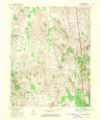
1969 Map of Robards
USGS Topo · Published 1971About this map
The town of Robards serves as the central hub for this Henderson County landscape during the late 1960s, a period defined by the convergence of agricultural traditions and the petroleum industry. Numerous Oil Wells pepper the terrain between Canoe Creek and Grimes Creek, illustrating the extensive energy extraction taking place alongside local farming. Family-named landmarks such as Agnew Cem, Eakins Cem, and McMullen Cem indicate deep-rooted genealogical history throughout the countryside.
Find a feature on this map
37 named features on this map. Tap any name to fly to it.
Don’t see what you’re looking for? This feature index may not catch every label — zoom into the map to look around manually.
Map Details
Editions of this 1969 Robards Map
2 editions found
Other maps of this area

1905 · Newburg
USGS Topo · 1:62,500

1906 · Sebree
USGS Topo · 1:62,500

1908 · Calhoun
USGS Topo · 1:62,500

1914 · Henderson
USGS Topo · 1:48,000

1916 · Henderson
USGS Topo · 1:62,500

1949 · Sebree
USGS Topo · 1:24,000

1949 · Poole
USGS Topo · 1:24,000

1949 · Robards
USGS Topo · 1:24,000

1951 · Dixon
USGS Topo · 1:24,000

1951 · Poole
USGS Topo · 1:24,000