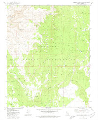
1980 Map of Robbers Roost Canyon
USGS Topo · Published 1980About this map
The Hualapai Indian Reservation dominates this 1980 survey, characterized by the dramatic verticality of the Aubrey Cliffs and deep drainage systems like Blue Mountain Canyon and Robbers Roost Canyon. The landscape is defined by the management of scarce water resources, marked by several artificial catchments including Babylon Tank, Twenty Pines Tank, and Hidden Valley Tank (Water). Notable landmarks such as the Tower of Babylon punctuate the high ground near Diamond Creek. While the terrain appears largely untouched by permanent settlement, a network of unimproved roads and a Jeep Trail navigate the plateaus, suggesting the area's use for ranching or resource access. Several Borrow Pits and Borrow Pits further indicate localized human activity and maintenance within the reservation boundaries during the late 1970s.
Find a feature on this map
18 named features on this map. Tap any name to fly to it.
Don’t see what you’re looking for? This feature index may not catch every label — zoom into the map to look around manually.
Map Details
Editions of this 1980 Robbers Roost Canyon Map
This is the sole edition of this map. No revisions or reprints were ever made.
Other maps of this area

1886 · Diamond Creek
USGS Topo · 1:250,000

1892 · Diamond Creek
USGS Topo · 1:250,000

1948 · Williams
USGS Topo · 1:250,000

1954 · Williams
USGS Topo · 1:250,000

1956 · Williams
USGS Topo · 1:250,000

1960 · Williams
USGS Topo · 1:250,000

1961 · Williams
USGS Topo · 1:250,000
1967 · Frazier Wells
USGS Topo · 1:24,000
1967 · Peach Springs NE
USGS Topo · 1:24,000
1967 · Diamond Peak
USGS Topo · 1:24,000