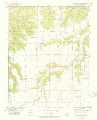
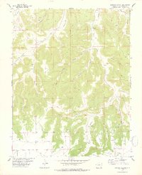
1978 Map of Robbers Roost Canyon
USGS Topo · Published 1978About this map
Robbers Roost Canyon and its complex network of seasonal drainages define this Las Animas County landscape during the late 1970s. The map illustrates a remote ranching economy, centered on the Platt Ranch and nearby infrastructure like several Landing Strips. Public life in this sparsely populated region is anchored by the Cedar Hill School and a small Cem, showing the enduring footprint of rural education and community even in isolated terrain. The water system is characterized by numerous seasonal flows such as Dinner Branch and Two Butte Creek, which are supplemented by vital water sources like Grape Spring and other unnamed springs. Named features like Horse Canyon, Matthews Canyon, and Dugout Creek reveal a naming convention rooted in the topography and early land use of the High Plains transition.
Find a feature on this map
15 named features on this map. Tap any name to fly to it.
Don’t see what you’re looking for? This feature index may not catch every label — zoom into the map to look around manually.
Map Details
Editions of this 1978 Robbers Roost Canyon Map
This is the sole edition of this map. No revisions or reprints were ever made.
Other maps of this area

1891 · Higbee
USGS Topo · 1:125,000

1892 · Mt Carrizo
USGS Topo · 1:125,000

1893 · Higbee
USGS Topo · 1:125,000

1955 · La Junta
USGS Topo · 1:250,000

1958 · La Junta
USGS Topo · 1:250,000

1968 · La Junta
USGS Topo · 1:250,000
1971 · Plug Hat Ranch
USGS Topo · 1:24,000
1972 · Brown Canyon
USGS Topo · 1:24,000
1972 · Lost Canyon
USGS Topo · 1:24,000
1978 · Icehouse Canyon
USGS Topo · 1:24,000