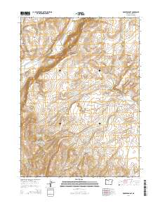
2014 Map of Robbers Roost
USGS Topo · Published 2014About this map
Robbers Roost and the surrounding high desert of Harney County are defined by a sophisticated network of water management features essential for ranching in this arid environment. The landscape is characterized by prominent geological formations such as Catlow Rim and the Basque Hills, which overlook a series of catchments including Holmes Reservoir Number Two and the Roux Spring Reservoir. These named reservoirs and springs, such as Lone Mountain Spring, reveal how early settlers and ranchers adapted to the terrain by capturing seasonal runoff from drainages like Box Canyon Cr and Long Hollow Cr.
Find a feature on this map
28 named features on this map. Tap any name to fly to it.
Don’t see what you’re looking for? This feature index may not catch every label — zoom into the map to look around manually.
Map Details
Editions of this 2014 Robbers Roost Map
This is the sole edition of this map. No revisions or reprints were ever made.
Other maps of this area

1955 · Adel
USGS Topo · 1:250,000

1957 · Adel
USGS Topo · 1:250,000

1958 · Adel
USGS Topo · 1:250,000

1962 · Adel
USGS Topo · 1:250,000

1971 · Square Mountain
USGS Topo · 1:24,000

1971 · Fields Basin
USGS Topo · 1:24,000

1971 · Coyote Gap SE
USGS Topo · 1:24,000
1971 · Acty Mountain NE
USGS Topo · 1:24,000
1971 · Hawks Mountain
USGS Topo · 1:24,000
1981 · Robbers Roost
USGS Topo · 1:24,000