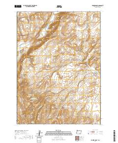
2020 Map of Robbers Roost
USGS Topo · Published 2020About this map
Robbers Roost sits at the edge of a high-desert landscape in Harney County, defined by its critical water sources and striking geological formations. The area's reliance on water management is evident through numerous collection points such as Funnel Canyon Reservoir, Oreana Reservoir, and Whiskey Canyon Spring Reservoir. These man-made features support livestock and wildlife in a region marked by the dramatic elevation change of the Catlow Rim and the Basque Hills. To the south, individual water sources like Roux Spring and Holmes Spring provide reliable points in the terrain near Lone Mtn. The map traces several drainages including Box Canyon Cr and Long Hollow Cr, which carve through the canyons and flats like Raz Lewis Flat, illustrating the remote and functional nature of this high-plateau environment.
Find a feature on this map
27 named features on this map. Tap any name to fly to it.
Don’t see what you’re looking for? This feature index may not catch every label — zoom into the map to look around manually.
Map Details
Editions of this 2020 Robbers Roost Map
This is the sole edition of this map. No revisions or reprints were ever made.
Other maps of this area

1955 · Adel
USGS Topo · 1:250,000

1957 · Adel
USGS Topo · 1:250,000

1958 · Adel
USGS Topo · 1:250,000

1962 · Adel
USGS Topo · 1:250,000

1971 · Square Mountain
USGS Topo · 1:24,000

1971 · Fields Basin
USGS Topo · 1:24,000

1971 · Coyote Gap SE
USGS Topo · 1:24,000
1971 · Acty Mountain NE
USGS Topo · 1:24,000
1971 · Hawks Mountain
USGS Topo · 1:24,000
1981 · Robbers Roost
USGS Topo · 1:24,000