
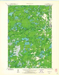
1938 Map of Robbins
USGS Topo · Published 1957About this map
The boundary between Vilas Co and Oneida Co cuts through a dense landscape of glacial kettle lakes and wetland depressions in this late-1930s survey. This era reveals a region transitioning from its logging roots toward a recreation and power-generation economy, evidenced by the Otter Rapids Dam and the nearby Otter Rapids Golf Course. The settlement at Robbins serves as a local hub south of the Eagle River, while the Chicago and North Western railroad provides a vital link for the scattered lake communities.
Find a feature on this map
117 named features on this map. Tap any name to fly to it.
Don’t see what you’re looking for? This feature index may not catch every label — zoom into the map to look around manually.
Map Details
Editions of this 1938 Robbins Map
2 editions found
Other maps of this area

1928 · Three Lakes
USGS Topo · 1:48,000

1930 · Robbins
USGS Topo · 1:48,000

1938 · Phelps
USGS Topo · 1:48,000

1938 · Minocqua
USGS Topo · 1:48,000

1938 · Three Lakes
USGS Topo · 1:48,000

1939 · Trout Lake
USGS Topo · 1:48,000

1939 · Cassian
USGS Topo · 1:48,000

1940 · Monico
USGS Topo · 1:48,000

1940 · Rhinelander
USGS Topo · 1:48,000

1942 · Cassian
USGS Topo · 1:48,000