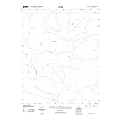
2010 Map of Robinson Peak
USGS Topo · Published 2010About this map
Robinson Peak rises above a high-plains landscape defined by expansive mesas and deep volcanic features in this Union County survey. The terrain is marked by the distinct elevations of Johnson Mesa and Griego Mesa, which overlook a network of seasonal watercourses like Archuleta Creek and the Dry Cimarron River. Small settlements and ranching outposts such as Doherty, Cruz, and King are connected by local routes including County Road A-34 and Cruz Rd. The map reveals a land shaped by geological history, featuring numerous volcanic landmarks like Jose Butte, Twin Buttes, and Cinder Butte. High-altitude water sources, including Griego Spring, Gringo Lake, and King Lake, punctuate the arid environment, indicating the critical water management required for life in this part of northeastern New Mexico.
Find a feature on this map
25 named features on this map. Tap any name to fly to it.
Don’t see what you’re looking for? This feature index may not catch every label — zoom into the map to look around manually.
Map Details
Editions of this 2010 Robinson Peak Map
This is the sole edition of this map. No revisions or reprints were ever made.
Other maps of this area

1954 · Raton
USGS Topo · 1:250,000

1954 · Dalhart
USGS Topo · 1:250,000

1958 · Raton
USGS Topo · 1:250,000

1958 · Dalhart
USGS Topo · 1:250,000

1962 · Dalhart
USGS Topo · 1:250,000
1971 · Trinchera Pass
USGS Topo · 1:24,000

1971 · Kiowa
USGS Topo · 1:24,000
1971 · Dale Mountain
USGS Topo · 1:24,000

1971 · Robinson Peak
USGS Topo · 1:24,000

1971 · Johnson Park
USGS Topo · 1:24,000