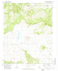
1971 Map of Dale Mountain
USGS Topo · Published 1974About this map
Johnson Mesa dominates this high-altitude landscape along the border where Colorado and New Mexico meet. The topographical detail reveals a complex network of volcanic landforms and water sources, from the prominent summits of Madrid Peak and Red Mountain to the essential water points like Dale Springs and Ross Spring. The drainage patterns are clearly defined, showing how water moves off the mesa into Taylor Canyon and toward the Dry Cimarron River. Human modification of this remote terrain is sparse but visible, marked by a few scattered roads, a Gravel Pit, and various Jeep Trails that navigate the slopes of Dale Mountain. This survey provides a precise look at the hydrology of the region, including high-mesa bodies of water such as Berry Lake and Bellisle Lake alongside seasonal drainages like Uña de Gato Creek.
Find a feature on this map
24 named features on this map. Tap any name to fly to it.
Don’t see what you’re looking for? This feature index may not catch every label — zoom into the map to look around manually.
Map Details
Editions of this 1971 Dale Mountain Map
This is the sole edition of this map. No revisions or reprints were ever made.
Other maps of this area

1892 · Elmoro
USGS Topo · 1:125,000

1893 · Elmoro
USGS Topo · 1:125,000

1897 · Elmoro
USGS Topo · 1:125,000

1912 · Raton
USGS Topo · 1:62,500

1914 · Raton
USGS Topo · 1:62,500

1954 · Raton
USGS Topo · 1:250,000

1954 · Trinidad
USGS Topo · 1:250,000

1955 · Trinidad
USGS Topo · 1:250,000

1958 · Raton
USGS Topo · 1:250,000

1958 · Trinidad
USGS Topo · 1:250,000